Thursday, September 26, 2013

Excellent opportunity income potential of $100,000+ in GIS Education & Consulting

Are you:
  • Interested in potential earning of $7500+ per week?
  • Skilled in ArcGIS?
  • Skilled in oral and written communication?
  • Interested in spreading the word about GIS, teaching and ready to be your own boss?
Then consider this:
  • Use proven methods and materials developed by a prominent provider (Kessler GIS) of GIS education
  • Teach on-line and on-site classes without the huge time investment in materials development – just add your own flair
  • Use classes to build your consulting and coaching business
  • Obtain a client list of approx. 3500 contacts
  • Receive a library of GIS books, GIS training materials, consulting and event planning books
  • Use contract formats proven effective for a small business
  • Receive consultation for on-line delivery methods
  • Receive interactive coaching from a long-time successful GIS educator
  • This is only for one person or group
As a teacher of GIS and ArcGIS for almost 30 years, I have developed and copyrighted a number of successful classes. I am retiring and this is your opportunity to use my materials as a foundation for your business. Most of the course materials are for ArcGIS Desktop v10.1. You have a great opportunity right now to upgrade the materials to v10.2 and add your own flair without the huge investment of time developing the classes. Lectures and demos are developed. Exercises are developed with chapters/page/index with information helping comprehension and learning. Exercises have numerous review questions to help engage students. I have invested the time into the lecture notes with supporting information. To help assess learning, I have written quizzes. You will receive copyrights for the course materials and many other business components. Please see my website www.kesslergis.com for information on the courses and their content.

I am not interested in a partnership, partial payments, or pay-as-you-go. Therefore you must purchase the content in whole. I am looking for realistic offers from people understanding what it is to run your own business or who truly want to learn.

I want to see you succeed and will help you in many ways. This is a business needing many skills: marketing, sales, website management, accounting, and of course GIS are among a longer list of skills. You should be willing to develop those skills, or be able to partner with others.

For more details on deliverables, support, purchase or other questions, please contact Bruce Kessler at bruce@kesslergis.com to schedule a discussion time. Please do not call without an appointment.

Kindest regards to all.

Bruce Kessler
Kessler GIS

Monday, July 22, 2013

Kessler GIS News July 19

Kessler GIS News
WORKING TOWARDS SELF-SUFFICIENT AND ENERGIZED CLIENTS

July 19, 2013


Whispers
and Praxes 

I thought this time around I'd list some of my favorites! Go to my Blog and see my latest. 


Sale on recoded classes!
There are many reasons for taking a live, online course. Unfortunately, these classes may not fit into your schedule. More and more people are taking self-paced courses and doing very well by them.

You may wish to take advantage this summer of the great sale I'm offering in July and August. All my recorded classes (at version 10.1) are 20% off during the month of July and August.

Go to Kessler GIS Web Classes for more information. 


Upcoming on-site classes
I have a couple sessions of my Python/ArcPy class coming up and they are open registration. This may be just the ticket for your training needs!
#20130813 Understanding and Using Python and ArcPy   $795
    August 13-14, 2013  221 W First Ave., Spokane, WA           This class is confirmed!
    Go to: www.kesslergis.com/onsiteclasses.html  for more information and registration

#20131014 Understanding and Using Python and ArcPy
   $795/$695     
    October 14-15, 2013  Sun River Resort, Bend, OR      
    notes: Save $100 when you register for the NW GIS User Conference as well               
    See  www.nwgis.org for more information and registration for this course


Upcoming web classes
Why take a web class from Kessler GIS? No one else gives you all these in one package.


  • Very competitively priced
  • Live presentations
  • Student engagement (you aren't allowed to sleep through these classes)
  • Small class size (no greater than 25, typically much less)
  • All sessions recorded for student review or catch-up
  • PDF of lecture & exercise notes, plus sample data
  • In class and after class support
  • Desktop sharing
Click the image above to see the New Schedule . But first, please review the course content and terms of service on my Course Listing pages

Friday, July 19, 2013

Whispers and Praxes (tips and tricks) For ArcGIS Desktop


New tools and expanded usefulness of ArcGIS changes in every version. I thought I would cover some quick topics that people seem to miss and are my favorites. I am listing these in no particular order. BTW, this is NOT 10.2.

  1. I find myself telling long-time users about map packages, which came about in v10.0. Why use map packages?
    • It's a perfect way to package your map document and ALL your data in one neat file. It may be big, particularly if you have imagery, but it is easy to create and creates a 'status quo' of your project.
    • Use as a backup. Keep in mind there are other ways.
    • FTP a copy to a partner, contractor, or as a FOIA response using ArcGIS Online. 
    • You don't HAVE to use ArcGIS Online for getting a copy to a partner. But hey, it's FREE!
    • Note: if you have a join, the properties don't seem to get copied but the table gets copied. You have to rebuild the join. I hope esri fixed that at 10.2.
  2. As with map packages, I still seem to be teaching long-time users about layer packages (v9.3). It basically packages up all the properties of a layer plus the data. 
    • Same advantages as map packages.
  3. So here is something I can't believe some people don't know yet... A layer file! (v8.0?) Don't be embarrassed if you don't know. Just read up on it and use them! (I had to add this, since I was going down this list.)
  4. Use Cntrl-F for searching.
    • Use it in Help while your searching a page for a string you're interested in.
    • Use it in ArcMap to open the Search window. 
    • In the comments, add some of your favorite uses for Cntrl-F.
  5. Calculating geometry values. You can calculate area, length, perimeter, centroid, and point coordinates in a table just by right-clicking the name of a text or numeric field and choosing Calculate Geometry. (v9.2) There's even a way to calculate Ares... (not Acres). Anyone use Ares??? Where is it useful? Comment below if you know.
  6. Tired of Full Extent tool taking you to some extent that is much bigger than your area of interest? Create a custom full extent. It's easy to do with the data frame properties. (v9.2)
  7. I love Connections! But the full pathname is sometimes ugly. You can rename the connection to anything you wish. (v9.2)
  8. Need to pan and don't want to click the pan tool? There are three options I'm aware of:
    • Press the C key on your keyboard and the tool switches to the pan hand.
    • Press your mouse wheel and pan away! (v9.2)
    • Use your arrow keys.
  9. You know how to zoom to a layer's extent by right-clicking and choosing Zoom to Layer. Shortcut this by pressing Alt and clicking on the layer. (v9.2)
  10. You can view multiple tables in ArcMap by dragging and dropping the table's tab to the position you want it. (v10.0)
  11. Want to print a table? Press Cntrl-P. (v10.1)
Do you have any favorite whispers or praxes? Tell me about them in the comments. 

Tuesday, July 2, 2013

Kessler GIS News July 2, 2013

Kessler GIS News
WORKING TOWARDS SELF-SUFFICIENT AND ENERGIZED CLIENTS

July 2, 2013

Using Excel Tables 

I continually get the question from students "how do I use Excel tables?" Well, I have a recorded session about using them. It takes a bit more than an hour, but covers a lot AND there are students asking numerous questions. Hopefully, this fills in some of your "chuckholes of knowledge"! 

Go to Using Excel Tables, sign in for free and view. 


Sale on recoded classes!
There are many reasons for taking a live, online course. Unfortunately, these classes may not fit into your schedule. More and more people are taking self-paced courses and doing very well by them.

You may wish to take advantage this summer of the great sale I'm offering in July and August. All my recorded classes (at version 10.1) are 20% off during the month of July and August.

Go to Kessler GIS Web Classes for more information. Here's the list of classes: 
 

What is GIS and ArcGIS Desktop? $80

Using ArcMap and Creating Simple Effective Maps 
 $160

ArcGIS Desktop: Managing Data  $200

ArcGIS Desktop: Geodatabase Power User $200

Using ModelBuilder $160

Understanding and Using Python & ArcPy in ArcGIS $352


Upcoming on-site classes
I have a couple sessions of my Python/ArcPy class coming up and they are open registration. This may be just the ticket for your training needs!
#20130813 Understanding and Using Python and ArcPy   $795
    August 13-14 2013       221 W First Ave., Spokane, WA                                                                 
    Go to: www.kesslergis.com/onsiteclasses.html  for more information and registration

#20130914 Understanding and Using Python and ArcPy
   $795/$695     
    September 14-15, 2013  Sun River Resort, Bend, OR      
    notes: Save $100 when you register for the NW GIS User Conference as well               
    See  www.nwgis.org for more information and registration for this course


Upcoming web classes
Why take a web class from Kessler GIS? No one else gives you all these in one package.


  • Very competitively priced
  • Live presentations
  • Student engagement (you aren't allowed to sleep through these classes)
  • Small class size (no greater than 25, typically much less)
  • All sessions recorded for student review or catch-up
  • PDF of lecture & exercise notes, plus sample data
  • In class and after class support
  • Desktop sharing
Click the image above to see the New Schedule . But first, please review the course content and terms of service on my Course Listing pages

Tuesday, June 25, 2013

Metadata! (Did I say UGH...?)

Yes, metadata... something most of us dread. The project is done, the data is done and we're oh, so tired of it! We've probably overrun our time allotment and the boss is yelling at us. Additionally, we just don't get all the changes, etc. that ESRI has run us through.

Well, I get it and I'm in the same boat. But we should and must do metadata. So here's a couple of recordings that may help you understand metadata better and be able to edit it smoothly. (I will admit I haven't watched the entirety of these three videos, but I will.)

Sara Moulton, GISP from Vermont Agency of Transportation posted these on VGIS-L and I just had to add them to my blog. Enjoy!

Working with Metadata in ArcGIS
http://video.arcgis.com/watch/2005/working-with-metadata-in-arcgis

Leveraging Metadata Standards in ArcGIS for Interoperability
http://video.arcgis.com/watch/1932/leveraging-metadata-standards-in-arcgis-for-interoperability

Creating and managing FGDC metadata in ArcGIS
http://video.arcgis.com/watch/486/creating-and-managing-fgdc-metadata-in-arcgis-10

Wednesday, May 29, 2013

"Coincidentally" the Geodatabase, Part 4


Finally! Part 4 -- what you've all been waiting for... or not...

Is it a coincidence you're reading this? Is it a coincidence you'll use this?

I've reviewed the plan below. This completes this series of blogs about working with coincident features in a geodatabase. Have I covered everything? Heck no! I've only touched on some of the capabilities. 

If you want to learn more, please attend my two geodatabase classes coming up soon! They are ArcGIS Desktop: Managing Data and ArcGIS Desktop: Geodatabase Power User. It's the second class where we get into some of the very powerful topology editing tasks, but if you're just getting into geodatabases, you should take the Managing Data class as a foundation. There is no time in the second course to back up and cover the basics from the first course. 

More information at Web Classes.

The plan:


This series of blogs is going to focus on feature coincidence. To get there will take a number of weeks of blogs to fully post this series. Here's my plan:
Part 1 -- introduce the feature dataset and how to add your shapefiles
Part 2 -- introduce topology and two very useful rules: Must Not Overlap and Must Not Have Gaps
Part 3 -- introduce working with coincidence and Area Boundary Must Be Covered By Boundary Of
Part 4 -- editing Area Boundary Must Be Covered By Boundary Of errors


Please note that I just don't have the time to go into the detail of this topic that you receive in my classes. There are many tweaks and issues to look at. We discuss many of them in the regular class.

The status:


In part 3 I covered the Area Boundary Must Be Covered By Boundary Of rule and pointed out some errors that were flagged by the software. There were significant errors that could only be easily found using the topology rules. 

I pointed out two problem areas that I review below (more information about these errors is added in Part 3). The first shows the zoning is not coincident with the north and east boundaries of the parcel. It's a bit difficult to see, but it's there!

This one shows some sort of averaging of the zone compared to the parcels.


The fix:


To fix these you need to start editing and open the Topology toolbar. 

Activate the Align Edge Tool (new in 10.1).

Point to the line you want to move. It shows as a dashed line. Note that my screen capture software changes the icon to a pointer. Yours should be different.

Click to select that line edge. It turns purple.

Point to where you want to move the edge. That line now shows dashed.

Click and it moves! You really don't have a visual clue that this has performed correctly. 

Validate topology.

Line has been fixed! The error is gone!

Let's move to the second coincidence issue I pointed out in Part 3. Again, activate the tool, if necessary. It builds a topology cache for the visible extent (which helps speed up display and selections). Point to the zoning edge you want to move and click. 

Click on where you want to move the edge. Notice the jog at the bottom of the dashed line.

Validate topology.  Notice the error still exists at the very bottom and across the top. The process only fixed what it could align to the edge to specified. 

Summary:


So, it's as easy as that! Knowing the power of your geodatabase will save you tons of time during editing, particularly when you are working on coincidence issues. Here's a couple of points to remember:
  • You must have a feature dataset with the two feature classes in it.
  • You must build a topology with rules.
  • You can use lots of tools to fix coincidence problems, but make sure you learn how to use the Align Edge Tool.
  • Remember to build topology where the errors are assigned to the feature class you wish to move. In this case, we wanted the errors assigned to the ZonesD feature class. With two feature classes in a rule, the errors are always assigned to the left one when reading the rule.


Thank you:


Thanks for reading this four-part series. I would appreciate any comments and I would really appreciate you signing up for one of my classes. You will get a lot more from the class than I can possibly relate here. They are very economical and packed with content.

Best regards, 
Bruce Kessler

Thursday, May 16, 2013

Wednesday, May 15, 2013

"Coincidentally" the Geodatabase, Part 3


This is part 3 of this topic about geodatabases. Why did I choose this picture??? Good question. A review of the plan is below:

The plan:


This series of blogs is going to focus on feature coincidence. To get there will take a number of weeks of blogs to fully post this series. Here's my plan:
Part 1 -- introduce the feature dataset and how to add your shapefiles
Part 2 -- introduce topology and two very useful rules: Must Not Overlap and Must Not Have Gaps
Part 3 -- introduce working with coincidence and Area Boundary Must Be Covered By Boundary Of
Part 4 -- editing Area Boundary Must Be Covered By Boundary Of errors
This information is taken in part from my ArcGIS Desktop: Geodatabase Power User class. For more in-depth detail, you can sign up for my class. More information at Web Classes.


Please note that I just don't have the time to go into the detail of this topic that you receive in my classes. There are many tweaks and issues to look at. We discuss many of them in the regular class.


The status:


Okay, so last time I covered building topology and using the Must Not Have Gaps and Must Not Have Overlaps rules for a single feature class. These two rules, I feel, are the basis for all polygon feature classes. 

Do all rules have to be implemented at once? No. To ease your error management issues, you can implement rules in stages from simple to complex. So I recommend running the Gaps and Overlaps rules on most polygon feature classes before doing anything else. Additionally, if you fix the simple errors first, then add more complex rules, the validation process will take less time to run. I believe in Part 2 I talked about how much time a validation could take. KISS rules here! (Keep It Simple, Stupid!)

New rule -- Area Boundary Must Be Covered By Boundary Of:


This rule is simply outstanding and I love it! It allows for all sorts of coincidence checking and I'm surprised at how few people use this rule. 

In the example below, I've created a topology between two simple feature classes: zoning and parcels from city data I have. For the most part, zoning should run along parcel lines in this city. Like many cities, they've maintained zoning and parcels separately and realize that they are not coincident where they should be. Now they want to capitalize on topology and set some rules to control coincidence. 

I created a FDS, then a topology named Aggregate. Following are images of the properties for the topology. 
Note the cluster tolerance happens to be very small. This is the minimum distance that can be used and it's automatically calculated by the software.

Note that I assume here that the parcels are "better" than the zones and I want the zones to "snap" to the parcels... at least moving 0.00328 ft. I do this by ranking parcels 'higher' than zoning. There may be issues with increasing your cluster tolerance and you should test your amounts. For instance, you may want to move your zones up to 10 feet so they would basically "snap" to the parcels. Remember, tough, this cluster distance is also applied to your parcels perhaps making other problems you hadn't planned on. We do this comparison in the class and it's quite fun and informative to see the results.

I only added one rule in this example -- "Are Boundary Must Be Covered By Boundary Of". I may also be interested in "Must Not Overlap" and "Must Not Have Gaps", but with these feature classes I had already run those two rules and now don't need them at the moment. Yes, you can remove rules once you've cleaned up your errors. 

Let's now look at some results. 
I would call this some 'dirty' data. There are many coincident errors. But, this provides lots of learning! Let's zoom into an area towards the upper right. I'll also change some of the symbology to help in deciphering the issues. Also, the image will be large to help see the full resolution of the problem. So if this blows the page size, I'm sorry. 

Looking at the legend in the Table of Contents, you see that errors are pink. Parcels are outlined in red (and no fill color). Zones are outlined in black and filled with purple. You can observe there are two edges of this parcel that are not coincident.

By turning of the visibility for the errors, you can see the black and red lines pulling apart from each other at the top and right sides.

Let's look at one more location where it's obvious that the zoning line was developed as an average of the parcels. Do you want that? It's up to you. But at least you can see the errors and fix them if you wish. 
This image shows the pink errors displayed.

Turning the errors off, you can see the zoning lines that are very different from the parcel lines.

Summary


Well, now you've seen some errors that are highlighted by building topology. In the last part of this series, we'll look at some tools to edit and repair errors. 

Upcoming classes


If you really want to get a lot deeper into geodatabases and topology, sign up for ArcGIS Desktop: Managing Data and ArcGIS Desktop: Geodatabase Power User. If you've read this far and enroll in either of these two classes that are scheduled below email me and I will refund 5% to your credit card!

Click the image to follow the link to the web pages. 


Thank you.


As always, I appreciate your comments, suggestions, and even spelling correcetions!
Happy Geodatabasing! 

Tuesday, May 7, 2013

"Coincidentally" the Geodatabase, Part 2


"Coincidentally"

This is part 2 of this topic about geodatabases. Below is a review of where we're at.

The plan:

This series of blogs is going to focus on feature coincidence. To get there will take a number of weeks of blogs to fully post this series. Here's my plan:
Part 1 -- introduce the feature dataset and how to add your shapefiles
Part 2 -- introduce topology and two very useful rules: Must Not Overlap and Must Not Have Gaps
Part 3 -- introduce working with coincidence and Area Boundary Must Be Covered By Boundary Of
Part 4 -- editing Area Boundary Must Be Covered By Boundary Of errors

This information is taken in part from my ArcGIS Desktop: Geodatabase Power User class. For more in-depth detail, you can sign up for my class. More information at Web Classes.

Required software: 

Standard or Advanced version of ArcGIS Desktop (it used to be called ArcEditor and ArcInfo) version 10.1. (Much of this can be done with older versions of the software. I cannot keep track of what all works and doesn't work with the older versions.)  Since we will be building geodatabases in this series, Basic ArcGIS (ArcView) users don't have all the capabilities.

Topology:

In simple terms, topology is a set of spatial rules ensuring geometric relationships or how features exist in relationship to their neighbors. There are 32 rules you can work with. Here is one common rule.

Why use topology? The easiest reason to use topology is to check and improve your data. Spatial integrity is important to most users.
When you model geographic features, you may find that you want to model some features that have spatial relationships with other features around them. Countries might be modeled such that adjacent countries meet without gaps along a common border line but never overlap. States or provinces could be modeled such that they fall exclusively within one country. Streets may be modeled such that two streets always meet at an intersection and never share a segment. Bus stops may be modeled such that they must always occur on a street or certain type of street. These relationships are maintained in the geodatabase through an association called a topology.
Topologies enable richer analytical functions in your GIS. For instance, geometric networks are a special kind of topology and allow routing and upstream/downstream modeling.
Topologies also allow you to perform sophisticated editing. For instance, you can edit a county boundary at the same time as a city boundary or a road if they are in fact, coincident (which is the objective of this blog). 
Why are you not using topology? (Well, in fact, you might. But, if you aren't...) Many people wait to build topology because they’ve seen or heard about involved designs taking weeks or months to build, test, and implement. They just don't have the time for an involved design.
You don’t have to wait! You can apply and capitalize on some of the benefits of topology, such as Must Not Overlap or MustNot Have Gaps. Very simple rules that help immediately and powerfully!
Certainly, your organization may want to construct a complex schema, but there is no reason not to start with a few baby steps and build up from there.

Creating Topology:

A topology is a set of properties. Right-click on a feature dataset (which you learned about in the last part) and choose New > Topology. 

Name: 
Each topology must have a name. Be sure to name it something that makes sense for your application.

Cluster tolerance: 
Cluster tolerance is the minimum distance between vertices of features. Vertices that fall within the cluster tolerance are defined as coincident and are snapped together. This may affect endpoints, vertices along a line segment, or lines of adjoining features or feature classes.
Image extracted from the ESRI help documentation

The cluster tolerance is very important to establishing topology. It basically suggests that two points describing the same or similar features cannot exist on top of each other. For instance, a line would not have two exact points describing the shape of the line. Cluster also ‘snaps’ features together such as the figure above. In this example, the software connects these two features together and eliminates one vertex. Hopefully, this would eliminate some ‘Must Not Have Dangle’ errors.

Rank
Ranking your feature classes is very important since you may not want all your data to move during the verification of rules. A rank of 1 is the highest rank, meaning it is less likely to move. If you have two feature classes with one ranked 1 and the other 2, then the features ranked 2 will move or snap (the to maximum of the cluster) to the associated features that were ranked 1. This implies an intrinsic level of accuracy or reliability for the rank 1 data.
Bear in mind, just because you have a rank of 1 on a feature class does not mean that that data won't move. The cluster tolerance can and will move your coordinate data.

Rules
There are 32 possible rules you may use (but not all apply to all feature classes). These are organized by the types of features they work with: points, lines, and polygons. I use the chart supplied by ESRI as my first reference for rules. You can find this (if you have a local install) at 
c:/Program Files/ArcGIS/Desktop10.1/Documentation/topology_rules_poster.pdf


Reading rules takes a little practice and there is more help in the esri documentation to help you with that. I suggest you also read further in the documentation and find out all you can about each rule.

The Must be Larger Than Cluster Tolerance rule: This rule is applied within each line or polygon feature class used in a topology. Vertices that fall within the cluster tolerance are defined as coincident and snapped together. Any polygon or line feature that would collapse when validating the topology is an error.

Validating Topology:

After setting rules for your topology, you will need to validate the rules. During this process two major activities take place: cracking and clustering.
Cracking happens when the vertex of one feature in the topology is within the cluster tolerance of an edge of any other feature in the topology. The topology engine then creates a new vertex on the edge (cracking) to allow the features to be geometrically integrated in the clustering process.
Clustering happens next. All vertices of any feature class that participate in a topology can potentially be moved if they fall within the cluster tolerance of another vertex. Vertices of higher-ranking features will not move towards lower-ranking features, but vertices of equal-ranked features will be geometrically averaged. For instance, end points have a higher rank than edges, therefore the edge will crack and move to the endpoint.
Image extracted from the ESRI help documentation


The combination of cluster tolerance and ranking controls your result during validation. Results may be different than shown above.
You may wish to run multiple tests changing ranking and clustering so you fully understand what will happen with your data before you implement the rules and parameters on your full database. If you choose to do this, make a copy of your data before you start! Validation can not be reversed – at least in ArcCatalog!
I once had to create a dataset of all the roads for 5 counties in Washington. They needed to be "topologically correct" in that all roads must connect correctly, there was to be no overlaps, and a few other basic needs so that transportation modelling could occur. The roads for each county were in various states of "cleanliness". Suffice it to say that they were NOT clean. I had intersections that did not intersect, county boundaries that "shifted" the data (as they were collected by different people and methods), I had duplicate lines, I had overshoots, and I had many other small errors. All these roads were segmented in that they started and stopped at each intersection. I had a couple hundred thousand road segments. Validation took about 150 hours! Now this was a while back when I didn't have as powerful a machine. The point here is that this process may take a huge amount of processing time. 
There are ways to help organize and reduce your work when validating a topology, but that's beyond the scope of this blog. Read the documentation, test your ideas on SMALL sets of data, think about your goals and critically evaluate your results. I can tell you by experience, I've been very surprised by some of my results.

Errors:

Validation finds errors. An error is a violation of a rule.
An exception is an error that you have determined should be allowed, such as Roads typically have lots of dangles so you may wish to ‘Except’ them. The exception might be a cul-de-sac or a road that actually dead-ends.
Dirty areas are regions surrounding features that have been altered by editing after the initial topology validation process and require an additional topology validation. This additional verification may well create new errors which you may need to take action upon.
All of these help you keep track of and identify ‘issues’ in your data. Just remember, an issue may not be a problem or even a data error. 

Visualizing Errors:

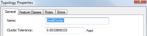
Here are the properties for an example topology: 
Note the cluster tolerance happens to be very small. This is the minimum distance that can be used and it's automatically calculated by the software. You can increase the cluster tolerance, but why in this case? Keep the data as precise as originally collected.

When applying rules to a single feature class, ranking is irrelevant. 

I've applied two simple rules that I feel are basic for most parcel feature classes. Parcels need to be full coverage and non-overlapping. 

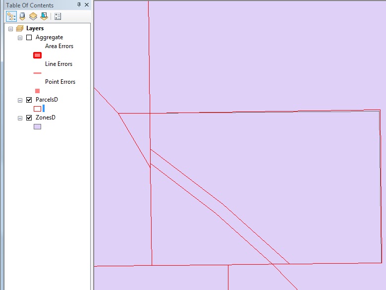
Okay, so now let's look at some results. 
Above, shows an error highlighted in pink that goes around the exterior of all the parcels. This error always occurs with the Must Not Have Gaps rule. If you look closely in the middle of the densest parcels (upper middle), you will see a pink spot. 

Zoomed into that spot, you can see very easily that a parcel is missing. This is an error related to the Must Not Have Gaps rule. It's very easy to locate gaps in your data, particularly when you have 1000's of polygons to look at.

Zooming into the pink blotch towards the lower right of the parcels, you will see a lot of parcels not only outlined but filled in as pink. These happen to be exact duplicates of parcels. What likely happened here is that this was an area of development that got updated and an insert was performed twice. You would never be able to visualize this issue when looking at the parcels, whether or not you filled them in with a solid color. Additionally, there seems to be a line problem, yet we are working with polygons. In the next part of this blog, we'll take a look at this error, and others to see what is going on. 

Errors can be visualized a number of ways. You also get a report of all the errors to help you sort out what is happening. There's not enough room in this blog to go into these other tools you have available. Again, this topic is a subset of the my ArcGIS Desktop: Geodatabase Power User class. For more in-depth detail, you can sign up for my class which is coming up in a couple of weeks. More information at Web Classes.

Notes About Topology:

  • A topology must be in a feature dataset (FDS)
  • All feature classes involved in a topology must be within the FDS
  • A FDS may have many topologies
  • A feature class can be involved in only one topology
  • A feature class may have many rules applied to it within that topology
  • All points, lines and polygons have the potential to move.
  • Just because a feature class can only be involved in one topology doesn’t mean that it can’t be involved in multiple rules.
  • When creating or validating a topology, an exclusive lock is required (since this is a schema change and will likely be moving data). An exclusive lock can only be acquired if no other locks—shared or exclusive—are already on the data. If there are already other locks on the feature class or table, ArcCatalog will not be able to establish its exclusive lock, and the schema will not be editable. Once an exclusive lock has been acquired, no shared locks can be applied, so the data will not be accessible in ArcMap or ArcCatalog. A common ‘shared lock’ that will prohibit the construction of a topology is an ArcMap document open and ‘reading’ the data

I need your help:

This sounds really silly, but I love the beginning image and having Dr. Evil and Minnie Me for the first two posts, but now I'm running out of ideas for the opening image! Any ideas for part 3 and 4?

As always, I appreciate your comments, suggestions, and even spelling correcetions!

Happy Geodatabasing!